JACKSON HOLE
CURRENT MAPS
FORECAST MAPS
OTHER PAGES
BUSINESS STUFF


Alaska Weather Page
Current Satellite, Radar, Surface Maps, Observations,
Web Cams, & Upper Air Charts. Computer Models, etc.
All for the State of Alaska
Quick-Click to: Current
 Maps
Surface
Obs
WX
Cams
Upper Air Soundings Forecast Models NWS Products NWS
 Links

       Call 907.523.8900    
Current Maps
Satellite Photos Satellite Loops Radar
Surface  
Maps
Upper Air Charts
US/Pac IR US/PAC IR Loop Alaska Mosaic 
All Radar sites
Fronts 850 mb
US/PAC WV US/PAC WV Loop Fairbanks Aviation 700 mb
PACIFIC IR PACIFIC IR Loop Kenai
Anchorage
Icing Map 500 mb
Alaska IR Sat Alaska Loop
IR
Middleton Is.
Valdez
Turbulence Jet Stream
Pacific/AK IR Loop     new15.gif (214 bytes)      
US/PAC  IR Loop US/PAC WVLoop      
Alaska Vis

Alaska Loop
VIS

King Salmon
Katmai N.P.
SFC OBS Map  
Alaska WV Alaska Loop
WV
Biorka Is.
Juneau & SE AK
Zoom Sfc Obs
SouthCentral AK
 
AK SAT
Big View
AK Statewide
Vis
loop
Nome Zoom Sfc Obs
SouthEastAK
 
SouthCentral AK Sat SouthEast AK Sat Southeast AK Loop Regional Sfc Obs
All AK,YT, BC
Station ID
alphabetical
ALL AK SAT Sat/Radar/Weather Map Help Key to Map Symbols

Other NWS Links

National and Alaska Map RADAR Links

 CWSU, Center Weather Service, ANC

AAWU, Alaska Aviation Weather Unit

NWS Anchorage Office

  Denali Page

NWS Glossary

NWS Acronyms & Abbreviations

Area Forecast Discussion Help

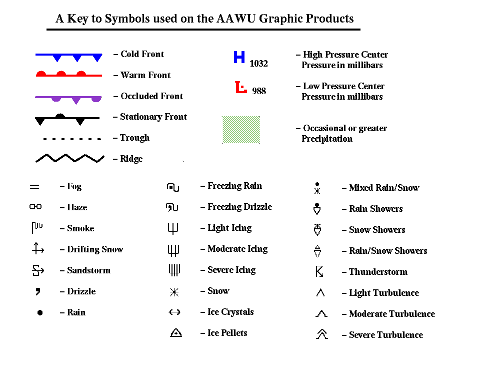
  Print a copy of this for reference when using maps

  Back to Top


Surface Observations
Info for all Alaska Sites
use this to access map with lots of clickable info, including meteograms
Valdez Anchorage Yakutat
Thompson Pass Seward Skagway
Cordova Kodiak Haines
Middleton Is. Whittier Juneau
Gulkana Palmer Sitka
45-Mile Rich. Hwy Hatcher Pass Worthington
19-Mile Rich. Hwy 18-Mile Snotel Eaglecrest Summit
Western Chugach Alaska Railroad Snotel Data
Juneau Wind Info Juneau Climate Info  

     Back to Top

Regional Surface Obs
All Alaska Hourly Observations
South Central MesoNet Obs
  Buoy Observations
 Hourly Observation Round-up by Region
Alaska Aviation Weather Center
SNOWDEPTH MAP    new15.gif (214 bytes)
 Weather Cams
Alaska Web Cam from FAA & NOAA
DOT Web Cams Other Web Cams

Back to Top


Upper Air Soundings
 
Clickable Map of USA and all AK Soundings
Anchorage Fairbanks Yakutat
Kodiak McGrath Juneau
King Salmon Cold Bay Site Map

Back to Top


Forecast Maps/ Models
Surface Upper Air Models
TV Tonight 6hr 6000-ft. Wind NWS: NAM/GFS
TV Tomorrow 12 hr 6,000-ft Wind  UWYO: NAM AK
TV Next Day    6 hr 9,000-ft. Wind UWYO: MRF
24-hr. Sig. Wx 12 hr 9,000-ft. Wind UWYO: UKMET
36-hr. Sig.Wx AK 6000-ft.Wind  
48-hr. Sig.Wx Jet Today MM5-nam
60-hr. Sig.Wx Jet Tomorrow MM5-gfs
24-36-48-60 hr Maps    
NAM Vertical Time Cross-Sections & Meteograms
    Palmer   SY01266_.WMF (626 bytes) Yakutat SY01266_.WMF (626 bytes)
Anchorage SY01266_.WMF (626 bytes) Haines SY01266_.WMF (626 bytes)
Kenai SY01266_.WMF (626 bytes) Skagway SY01266_.WMF (626 bytes)
Valdez SY01266_.WMF (626 bytes) Juneau SY01266_.WMF (626 bytes)
Cordova SY01266_.WMF (626 bytes) Sitka SY01266_.WMF (626 bytes)
All Alaska X-section & Meteogram Map

Notes:
1) Cloud cross-sections ( e.g. Palmer) show vertical time-profile.
2) Surface info is in the Meteogram = SY01266_.WMF (626 bytes)
3) NAM is the North American Model.


Help!  with NAM Cloud Cross-Sections

Help! with NAM Meteograms

Back to Top


Model Output Statistics (MOS)
Map of All ALASKA  MOS Stations AVN & MRF
       GFS
Global Forecast System
NGM 
Nested Grid Model Output


 Quantitative Precipitation Forecasts
24-Hours 48-Hours

Back to Top

NWS Forecast Products
Weather Discussions and Outlooks
AK Weather Summary Anchorage Forecast Discussion Juneau Forecast Discussion
AK Extended Forecast Discussion   Fairbanks Forecast Discussion
NWS  Zone Forecasts
Western PW Sound Eastern PW Sound Southeast AK
Anchorage Valdez Glacier Bay
Homer Cordova Haines
Girdwood Yakutat Juneau
All South Central Zones All Chugach Mountain Zones All Southeast Alaska Zones
Anchorage to Kenai
to Talkeetna
Valdez to Thompson Pass Girdwood to Cordova Haines/Skagway
to Juneau to Sitka
* Notes:
1) Weather Summary tells you what's been going on the past 24 hours around the region. 
2) The Discussions  tell you what's going on now and in the near future, the rap from their meteorologists. 
3) The Extended Discussion is nationally oriented but has a blurb at the end about AK weather in the 3 to 5 day period
.
4) NWS Zone Forecasts: Individual Zones and also grouped together to cover certain regions.

Back to Top


National Weather Service Links
Anchorage NWS Juneau NWS Fairbanks NWS
Alaska  Aviation Unit Alaska Regional Office AK River Forecast Center


This page sponsored in part by:


bar.jpg (2914 bytes)


For questions, comments, problems with links or just to say hello!
You may also e-mail us with suggestions about other links you would like to see, or to tell us about any misspelled words you are bound to find within this site.
mail@mountainweather.com


Back to Top